Saturday, July 2, 2011

Mt. Democrat, Cameron, Lincoln and Bross

Hard to believe last week's trip was already a week ago – I can get used to these weekly adventures.

On the menu for this trip was a group of 3, 14,000 foot peaks known as the Lincoln group near Breckenridge, Colorado.

Our overnight trip included some extras not on the menu including storms, ice, and mines. The pictures tell the story more, so they can do most of the talking for the actual trip.

We packed up the car with anything and everything we could possible need for the 2 day trip west and hit the road early Thursday morning. It wasn't long before the cloudy hot weather turned into an endless torrential down-poor, but we inched up further and further to Breckenridge where we stopped for food, a walk, and a contingency plan in case we couldn't do the intended mountains thanks to mother nature.

A bumper sticker for the wealthy folks in Breck

Soon we were racing up the hills near Alma and cresting the continental divide where the weather cleared and warmed.

Feeling philosophical, I pondered... If you put a ball at the continental divide, will it go to the Atlantic or Pacific ocean?

The road leading up to the Kite Lake trail head was specified as a “Rough 2WD road.” I agree. The foot-deep holes and streams racing across in combination with the mud and small boulders put my little Pontiac to a test and somehow, it ended up fine.

This area was once big time mining country. Gold and silver mines are all over out here, just daring to be explored.

So we did. First we came across an old mill dating back to the late 1800's. Though “off limits” to the public, we crept into it and soon found ourselves walking on the floorboards of what can only be described as a trip through time.

Run down walls and fallen plywood panels litter the area, but it was in remarkably good shape. We wanted to go up and explore the rest of it, but the clouds were building and a storm was brewing (again). We needed to get to our campsite.

Soon we reached the end of the road after seeing tons of other cool mineshaft daring to be explored. About .7 miles from the trail and at 12,000 feet, a snowdrift still stretched across the road. Home at last we decided and parked on the precarious slope.

The threatening sky seemed to say “stay in your car.”


We dared to say “hold on... Let me see the trail.”

And back to the “mistakes” we are...

We hiked partway up the road hoping to see the trail conditions so we could plan for the following day's hike. Soon though, a pelting ice ball hit my jacket.

And another.

The signpost was right there, and as I ran to check it out, a bolt of lightning struck just a quarter mile to the south along the ridge – way to close for comfort.

Being trapped above treeline in a storm like that is a big no-no, and as we raced back to the car, the constant thunder and lightning made sure we knew this and knew it well.

Dumping hail and rain at this point in combination with the 30mph winds, this was NOT what we wanted. We ran as fast as possible back to shelter across the accumulating hail, and luckily, we made it back safe, thought exhausted from the sprint at altitude.

I have never run for my life like that before. Ah, memories :)

“Safe” in the car now, we listened upwards of 15 minutes as the hail, wind, and rain pummeled my car and thought how lucky we had just been. It is really amazing how different a thunderstorm is when you are so close to the action. Thunder roars louder and lightning is even brighter, adding an element of fear to a deadly equation.

Eventually, it passed and we had a break to set up camp in the chilly wind and venture out to a nearby mine Mel noticed on the way up.
Creeping into the narrow cutout in the rocks, I took pictures, and this strange one showed up with a flash. We had headlamps on and it was moist in the cave. Breathing was fine, and there was no dust or noticeable smoke or gas or particles in the air, yet the camera caught these 2 bizarre shots.

Think what you will.

It ended about 30 feet in, unfortunately, and we turned back and went back to camp to finish setting up. There are so many mines around this area, I just wish more were stable-ish like this one. To live in a mining camp like what was here 50 or 100 years ago would have been an incredible experience to witness, especially by today's standards.

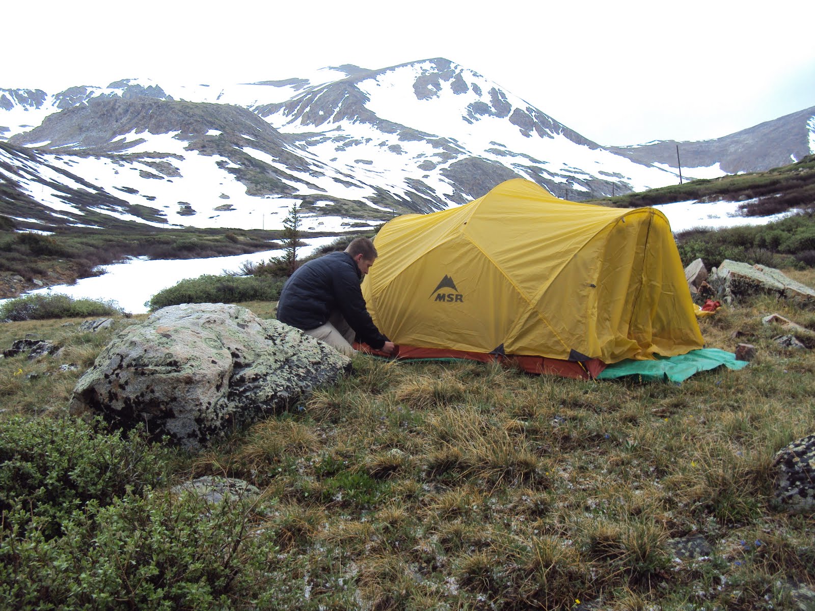
We had a few minutes before the next storm came racing down the ridge and soon were hunkered down in my tent that, at times, bent almost flat. Thank you MSR for making a good product haha.

The clouds broke, and we boiled some water for dinner and readied our packs for Friday before sleeping.

The trusty Beatles clock chimed out at 4 a.m., and we took down camp and watched the clouds drape across the peaks we were hoping to ascend. Hoping it cleared, we took off along the now iced over ground.

The storm last night had left a layer of water and hail that froze over during the night. What is normally an easy Class 2 hike had been transformed into a giant ice scramble.

The steepest snow leading up to a ridge near the saddle of Democrat and Lincoln had gotten so bad that, without trekking poles or crampons, it was not possible. I was able to get about ¾ of the way up before the ice got too hard to dig in to with my boots. A long, bumpy slide (though ridiculously fun!) was the result, and we decided to take a longer way up the ridge in hopes of bypassing the impossible ice.

We climbed up some class 2 and 3 scree steeply positioned on mountainside and encountered, yes, more snow and ice. These traverse spots were smaller but much, much steeper. Pictures do not do it justice at all, and it truly was enough to make even me dizzy – not the easiest of feats. Using a rock and my boot, I dug in a path of holds about 15 feet long 3 times above the 100 foot drop into rock, ice, and cement-like snow.

Growing tired and cramping up, the only thing that made me keep going was realizing that a crowd of nearly a dozen hikers had formed near our initial ascent spot. Puzzled, they looked on as we traversed across what looks, from there, as an impossible route.

If only cameras could do the pitch justice...

After nearly an hour of working on that route, the sun had hit the area we tried originally. This allowed the average hiker and onlooker to simply walk up the now slushy snow.

I like our way better.

We were now on the trail and quickly climbing the rough trail up Mt. Democrat's false summit. Once there, it wasn't long before we were at the summit - 14,148 feet. Looking out, this was the first summit we had made there there are mountains all around us still snow capped.

The descent for those of us with long strides was quick, and lunch was the standard tuna and Clif bars before we began our climb up the ridge to Mt. Cameron at 14,238 and eventually to Lincoln. This trail looked tricky from the summit of Democrat, but turned out to be an easy-ish (though steep) walk up a very groomed, defined trail.

Cameron's summit was a flat expanse of small rocks and Martian dirt with the occasional spider and mine for good measure. Lincoln was only a few dozen feet higher, and we were soon walking on the edge of the world in the Mosquito range to it's summit.

I would have to say this is the most beautiful summit we have done to date. There is simply too much for the eye to take in, and pictures cannot begin to grasp the enormity of it all. Everything looks as if it is from a calender, and you feel as if, while walking near the mines, you are traveling through time.

Pictures tell the story, and the feeling of being so high for so long is unlike anything words can describe.

After a 15 minute rest overlooking the world it was on to Mt. Bross along an easy dirt path and old mining road along a ridge.

Signs say that this is “not accessible” to the public. Ownership issues have made this one of many peaks that are not public lands anymore, to which I say buck the system. You can't own a mountain, especially one of the highest ones in the state. We hiked up, didn't get arrested, and soon found ourselves at the final peak for the day.

The expanse of this flat summit looks martian-like as well, tempting the eye to see the drops on all sides.

The bypass trail leads down a gully of scree, fully lined with even more mines and slippery loose rock. The mines had all long-ago collapsed (or been destroyed?), but they still tempt the eye to look in and dare to be explored.

The tricky descent was more of a controlled fall/slide for 2,000 vertical feet, and we soon found ourselves bushwhacking the final stretch back to the car along the snow-topped river.

Reflections:

Weather:

Obviously, this is a no-brainer, but it really came to play on this trip. The weather dictates what you do, how long, and when to worry. In our daily lives, we rarely even mention it as we sit inside or in our cars. Yet, up the mountain, it can truly be the difference between life and death... between a successful summit or an early trip home. Crazy to think that something so simple dictates so much, at least in the outdoor enthusiast's world.

Going bigger:

I realize these peaks we have done are nowhere near the Capitols and Maroon Bells of Colorado – some of the toughest routes in the state. Instead, they are just tricky, high, adventurous day hikes leading up to our eventual summit of the tough ones in the state. Not to say they should not count as epic hikes – we seem to have a way of making even the easiest of routes a difficult and deadly adventure.

I love that about our trips, and even if we start to think it's getting bad, we find a way to gather ourselves for the successful ascent. More than anything, they are fun and we work together. Even though we get off the mountain exhausted from what some would call an easy day, we know that we are well on our way to topping each of the toughest ones.

People train on mountains, and I feel that is what we are always doing. Training for bigger and better, getting more accommodated to the conditions of the mountains so that one day, bigger trips and maybe even K2 or Everest can come into the picture.

I read a quote today, and actually took note of it... something I almost never do. I feel it really puts a poetic spin on what I have always felt these trips mean to me.

“I learned that the richness of life is found in adventure. It develops self reliance and independence. Life then teams with excitement. There is stagnation only in security.”

-William Orville Douglas


Sunday, June 26, 2011

Mt. Bierdstadt and Evans via the Sawtooth traverse

*Click pictures for full screen

How great it was to break out the tent, load up the car and drive west to the mountain – a destination not visited for way too long.

After nearly 3 months of living my day-by-day life where internships at newspapers, working at the bookstore and constantly training for fall marathons occupy the majority of minutes throughout the day, Mel and I were finally able to both get two days off from everything.

Some people aim to only complete a 14er and move on. Not us. We had planned an entire day that include a hike up Bierdstadt, a traverse across the (in)famous Sawtooth, an ascent of Mt. Evans, a descent through a gully the dips nearly 3,000 feet nearly straight down, and a couple bushwhacking miles through a bogged area known as the Willows.

On our “weekend,” which happened to be Thursday and Friday, we drove two hours southwest into the picturesque village of Georgetown. This town, a rest on the way to a camping spot 3,000 feet higher, is seemingly frozen in time. It belongs in a black and white movie with its 150-year-old architecture and seemingly candyland-ish color schemes.

We walked around for a bit since we had some extra time, and what a trip through time it was. Everything was so central – so peaceful it seemed. From the school and church to the play structure and fire department, it was as if we were walking down main street in a movie, though I am not sure who had the idea to put high voltage near a water feature?

It was soon time to go up, and what would summer be without a construction project even at 10,000 feet. We received an escort up the mountainside and romped over the dirt mounds and rock piles. If I would have gotten stuck, at least we had company behind us... and yes he was moving right on my tail.

The road soon paved out and we were inching closer and close to Guenalla Pass where the trail began at 11,600 feet. The view from here is simply stunning, a recurring theme to present itself throughout this quick day trip.

We soon found a nice spot to park and car camp for the night just a mile from the beginning point of our hike. Nestled near a stream, we soon had camp set up, food figured out and a relaxing evening of fire-side chat planned.

It has been too long since I have car camped, and it is not ok. I blame it on not having a car for so long and not being back home to go like I did in high school every month, but I plan on doing it a lot more in the near future. It is so much more relaxed not worrying about packing and planning for a week long backpacking trip, though one of those needs to be on the agenda soon.

The night was early, and with plans of waking at 4 a.m. To get to the trailhead, we were soon asleep.

Thanks to the obnoxious ringing of the Beatles alarm clock I brought – a new tradition for overnight trips I think – we were soon on our way up the west side of Mount Bierdstadt. This hike was the easy part of what would begin our epic adventure for the day.

As we began, a runner whom we can only imagine as a semi-professional or sponsored athlete blew past us running up the 2,500 feet of rock and trail only to come right back down. His form was perfect – give me a few more months haha.

The sawtooth is the jagged part between left and right sides... go across that :)

Watching the sun rise over the rocky ridges from such a beautiful and majestic environment is unlike anything I have ever seen. Each time it happens, it seems more and more impressive. This was no exception as the rays first draped the peaks to our west and soon bathed us in its rays only later to leave more burns on my face.

We paused often. For some reason I wanted to take more pictures than usual. I guess there are worse things in life.

By 8 a.m. We were nearing the peak at 14,060 feet. There were only a few small snow fields to negotiate, and the rocks were relatively easy class 2 terrain. The most difficult part of this initial 3 miles of the hike was the ice from the small streams that run across the trail, but even this could be done by many average hikers.

Warm temps and clear skies greeted us, and the views, even from an “easy” hike like this, were equally as stunning as anything I have ever seen before.

We talked to a couple other peak-baggers and signed the registry while eating our breakfast of Clif Bars and water and planning our route for the remainder of the day. We were most concerned with the traverse, a class 3 climb that ultimately turned to class 4 by the time we were done.

We plotted our route and were soon descending sharply into an opening valley.

Parts of it seemed ok, but the repetitive ups and downs and constant rock scrambling take a toll. We descended through the boulder field about 400 feet while eying the trail just to northwest. We planned to bi-sect it through a snow-field – “mistake” number 1 for the day.

I say mistake lightly.

Soon we were back with the main “trail,” which was more like a guidance or cairns dispersed along the ridge – not a trail at all. We made our way along the steep apex of 2 worlds, trying carefully to not freak out about the thousands of feet of air below us on both sides.

A marmot that had followed us up came out to say hi

It wasn't long before we made a turn too early and found ourselves back in the snow waist deep, angled snow field.

“Mistake” number 2.

This isn't the kind of snow you play on – it is the kind that you can step wrong, begin sliding and not stop until you hit the lake 2,500 feet below.

The idea of this was amazing, terrifying and beautiful at the same time. Soon though we found ourselves stuck. We had made our way to an island in the sky it seemed, using careful teamwork to get across the unstable slope. The snow went nowhere on either side of us, and the rock face, which we estimate as a 5.5 top rope climb with drops to make you dizzy, was all we had to move on.

To make matters worse, we realized we had spent way too much time on this ridge. The time was nearly 11 a.m., and the clouds were building above – not the situation you want when you aren't even close to being in a safe spot in the event of lightning. We had to keep moving, but the questions was to where?

So we did climbed. Up.

Grasping each crack with our lives and trying not to look down, we soon found ourselves back at the cairns along the ridgeline – good news until we realized just how harrowing the the remaining portion portion looked in person.

Hugging the wall and negotiating the loose rock and dirt, we went up. And up. And up until the Sawtooth was able to be checked off of our to-do list.

To be fair, each person who said that it wasn't as bad as it looked was absolutely right. The worst part had been our little detour minutes before, and this was merely exposed. There was plenty of room to walk, believe it or not, and it really was a fun traverse across the sky as promised. Some tougher scrambling, yes, but definitely tame compared to what our future trips hold.

The clouds had cleared, and our plans to summit Mt. Evans today was still on the agenda despite the set-backs earlier in the climb.

Hugging the ridge line and moving towards the summit of Evans we hiked. It was a walk at this point through open boulder/grass fields that even contained flowers of the most rugged type at 14,000 feet.

We came from the peak on left, dipped down and then up the spike on the right

The rock scrambling continued until after another 2 miles of climbing, we reached the summit at 14,264.

This was not nearly as glorious of an achievement. I blame it partially on the tourist trap it had become. While boasting to have the highest paved road in the country, with it comes the hoards of people who know nothing about a mountain or even basic trail etiquette. They don't even move as two exhausted hikers try to make the push to the peak.

So it goes.

After a short lunch of tuna and bars (tuna bars seem like a REALLY good idea come to think of it...), we were heading down the cairned route to the opening of a gully that dips back to the area near Guenalla Pass. The steepest portion of the day was here as we inched our way down the tough terrain. Of course, a fun hike is not complete without some sliding which we soon came to appreciate.

It wasn't long before we were racing through the snow-fields, sliding as far as possible and hoping to keep the snow out of our boots before we were at the flat-land again,

It wasn't over yet, of course.

After pausing at a creek for pictures and water of the purest and cleanest sort, we soon found ourselves pushing through ankle-deep mud in a bog that attempts to swallow up anything that steps near it. Plus, we were bushwhacking through willow bushes taller than us that were unforgiving to visitors.

There was no trail through here – only small tributaries that go to a complex array of dammed up beaver ponds.

Veering south around another mountain, we were inching closer and closer to the main trail we had begun more than 12 hours earlier.

At nearly 6 p.m. We made it back to the car, changed and ate before embarking on the two-hour drive back to our “real” lives.

That is, until next week when we do a couple more 14ers on yet another adventure.

Reflections:

I mentioned mistakes earlier. Mistaken routes. Mistaken timing. At the time, they did seem like mistakes, and for a moment, it seemed as if everything was about to hit the fan... Hard. Things can crash down really fast, and we found ourselves in a dicey situation. Looking back, I am beyond glad that things played out that way. We traversed a suicidal snow-field more than once with spectators saying how crazy it all looked, rock climbed and pushed our bodies to the mental and physical limits and kept our composure. These little mistakes and the ways in which we handle them are how we train for the big issues that can come up while negotiating a tougher mountain. I cannot wait for that day to come.

Time spent:

We looked forward to this, like all of our trips, for weeks. It had been way too long since we did an overnight trip anywhere (since Canyonlands National Park). It is crazy how just looking at a guidebook that has everything listed about every mountain can give us an idea. Better yet, it is amazing how we can just run with that idea and make an epic trip out of it, caring so little about where to be and the worries surrounding us back home.

Looking forward:

We are hoping to bag 20 14ers throughout the summer, and this seems totally possible if we can continue these quick trips. Everything is so close to us, and having the mountains in our back yard is something I feel ridiculously fortunate about. So many adventures lay only an hour's drive from us. Thank you, Colorado.

Saturday, May 14, 2011

Summer Kickoff - Getaway to Rocky Mountain National Park

The faint sounds of dripping rain water and panic-stricken college kids gave way to a glorious sound of ice cracking and robin's singing their constant, springtime song.

Finals week had finally concluded. To cap off a long and arduous semester filled with both tedious and meaningless classes as well enticing and difficult ones, I did what seemed obvious - I went to the mountains.


Mel and I had planned this day trip about 2 weeks ago when I was stressed beyond belief with classes, work, projects, running, internship stuff, and of course money. But knowing that the day after my last final we would be heading up to Rocky Mountain National Park pulled me through, and the day finally came.

Soon we were heading up Big Thompson Canyon where it turns out the speed limit is 40mph, even on the flat and straight portions. Thank you officer.

Not even a threatening cop was going to stop this day from being totally relaxing, and shortly before noon we were heading down the trail to Mills Lake from the Glacier Gorge trail-head.


It wasn't long before the winding and confusing trails packing into the 8 feet of snow took us all over the valley before, thanks to the quick thinking of two direction oriented people (ha. ha.), we soon figured out where it was we had to be.

To be honest, I really didn't care where it was we ended up. Sure, Mills was the plan, but I was happy to just be outside. The temperature was near 70 even though there was still such an incredible snow pack, and the sun basked us in rays of warmth – I have the sunburn to prove it.


Wandering through the woods in an effort to intersect the trail, things just made sense again for the first time since Boston? Since Canyonlands? I am not sure, but it just worked. Everything was at peace, and that feeling of “I might actually have control of my life” overcame for the first time all semester I think.

By about 2pm we had reached Mills Lake, a beautiful expanse of water frozen in time at a point that lay at the base of Long Peak. Located at 10 thousand feet above sea level, Mills was an isolated place likely because the hoards of tourists struggled through the snow past about mile 1.


With the ridiculously warm temps, we lay on a rock near the melting lake and fell asleep. The sounds of cracking ice sheets that sounded like gunshots and dripping water from the hundreds of feet of rock around us woke me and put me to sleep simultaneously. For nearly a half hour, the sun baked my pale skin, and when I awoke I knew I had fried. I was strangely okay with it, and if that is the worst thing I have to complain about, so be it.


Things just seemed so peaceful up hear away from the throngs of city living and stresses of the world. The wispy, cotton-candy-clouds dispersed the suns rays around us, and it made packing up our days worth of food and gear dreadful. Why can't we just live here?


Around 4 we began out descent back to the trail-head through a meandering route following other people's likely confused and wandering tracks. We paused several times to look around – to look at what an amazing world rest just 45 minutes from our homes. Waterfalls and aspen trees as well as the scent of pine freshness and the sounds of a robin's song led us down to the parking lot.


From there, we went into Estes Park to walk around where it was even warmer before we made the extremely difficult decision to head home.


Though this was hardly our most adventurous, dangerous, or lengthy trip, it still served its purpose. To get away for just long enough and to rid ourselves of our struggles for an afternoon with nature. We both needed to get away, and it seems that this is a recurring theme.


But it seems that we cannot go more than 2 weeks without doing something to recharge. We did Sand Dunes in January and soon we were itching to get out again. That came in the form of Cameron Pass. Soon it was spring break and we did Canyonlands and Arches. Then a month later was Boston. Now 3 weeks later was this.

We are going crazy at the moment because we don't know when our next trip will be. We made a goal of having our next trip planned soon after returning from a previous one, but that has been sidetracked by a lack of money, unfortunately. Some people buy music and some go out to parties and spend money on booze, but instead we just put the cash towards gas money so we can go somewhere interesting for a week.

The idea of doing a Bryce, Zion, Southern California, and Grand Canyon loop still remains a possibility, despite concerns by some :) Likewise, a trip into Yellowstone and the Tetons is more plausible and tempting, but we have yet to set dates.

In the meantime, 14er season kicks up in a couple weeks, and there will be plenty of stories to come from that I am sure. Regardless of how many we get out to do (hopefully 20+), we always have Rocky to go back to and all of the endless miles of trails to explore.

What a summer it shall be.